
Edison Neighbors by Parcel
Edison public records can describe the lots around an Edison address, but they do not create a current roster for the block. Start an Edison block review with mapped parcels and tax blocks, then move to assessment and recorded-instrument evidence one lot at a time. Historical directories and library material serve a different purpose: they can document a named address or event in a particular year. The strongest Edison description states whether it concerns an adjacent parcel, assessed owner, recorded grantee, directory entry, or public event participant.
| Source | What It Shows About a Block | Access |
|---|---|---|
| Edison ArcGIS Nearby | Location and nearby mapped parcels or features | Public map |
| Edison-area Middlesex Parcels and Tax Blocks | Parcel and tax-block geometry or attributes | REST query and identify |
| Edison TaxDataHub | Assessed owner, mailing, location, and assessment context for each lot | Assessor-linked search |
| Edison lot, County Clerk Registry | Recorded instruments and legal descriptions for an individual lot | Browser, counter, or copy request |
| Edison State Library directories | Dated name and address entries for a year and section | Physical directory holdings |
| Edison library archive | Public events, organizations, photos, notices, and township publications | Digital collection |
| Edison Maplebrook study | Neighborhood planning context and recorded needs | County planning document |
| Edison 1963 organization inventory | Historical civic vocabulary and named local sections | Edison township publication |
An assessed owner or tax-mailing recipient may be outside Edison, may be an entity, or may differ from a person using the property. Edison parcel evidence therefore supports a property relationship, not an occupancy conclusion. An Edison map also cannot replace a legal survey.
Edison Neighbors Parcel-First Flow
Use a parcel-first flow for the immediate Edison block: GIS mapping, assessment, deeds for each lot, a historical directory, then an archive or dated publication. The Edison ArcGIS Nearby map provides Edison location and nearby-distance context. The county parcel service provides separate Parcels and Tax Blocks layers with query and identify operations. Capture only the public Edison parcel fields needed to understand the geometry and relationship.
The Middlesex County parcel-layer source displays the map service used to inspect parcels and tax blocks.
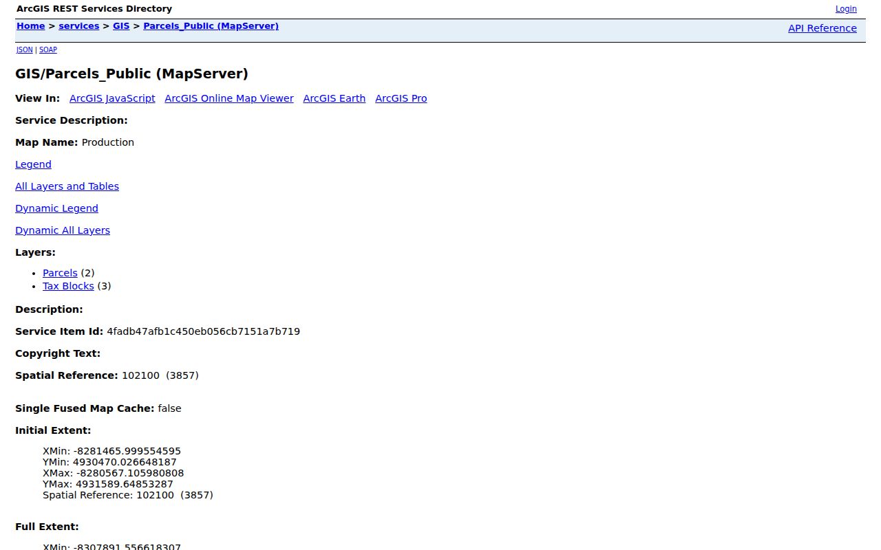
The parcel layer is most useful for drawing an Edison block boundary before checking records for any individual lot. Its geometry and attributes are mapped data, not proof of a legal boundary or present occupancy.
- Locate the subject address and save its exact property location, block, lot, qualifier, parcel ID, and date of the map check.
- Inspect the surrounding polygons and identify which ones are separate parcels, shared areas, roads, or public features.
- Open assessment evidence for each adjacent lot separately, keeping owner, mailing, and property-location fields distinct.
- Search the County Clerk index for each lot by lot/block, parcel ID, legal description, or party, then retain the instrument date and legal description.
- Use a dated directory or archive item only as a historical layer, with its year, section, page, and scope noted.
For a full named-street record trail rather than the immediate radius, use the Edison street directory. That route follows a longer address chain without treating every mapped parcel as a neighbor.
Edison Neighbors Need Separate Lots
The Edison-linked TaxDataHub search can use owner name, property location, block, lot, qualifier, and assessment or sales context. Record the Edison district, the tax year, and the parcel key. Then use the Middlesex County Official Records browser by lot/block, parcel ID, map number, legal-description line, instrument number, book/page, town, or party name. A street name by itself is not a unique land-record key.
Search every adjacent lot independently. County Clerk results can identify a recorded instrument and its parties, but a grantee is not automatically the person using a location. The assessment record may show an owner, a property location, and a separate mailing address. Label the finding as assessed owner, tax-mailing recipient, or recorded grantee rather than calling it a current neighbor.
The deed's Recital or Being Clause can cite an earlier seller and deed book/page. That reference supports a backward property chain. It does not turn a boundary description into a current person list.
- Parcel
- A mapped tax or assessment unit that helps connect a location to block, lot, and related record keys.
- Lot and block
- Local land-reference numbers used to narrow a property record within the municipality.
- Legal description
- The recorded language that identifies land by lot, map, boundary, or another legal reference.
- Recital or Being Clause
- Deed language that can point back to an earlier owner and recorded book/page reference.
Edison Neighbors and Common Areas
Mapped Edison proximity does not always mean an adjacent household. A polygon can represent a road, utility tract, park, common area, or condominium common element. Condominium master deeds and bylaws may be indexed under an association name rather than a street address. An Edison deed can also use a boundary description in a way that identifies land, not a person beside the property.
For a condominium or shared parcel, retain the unit exactly as supplied and determine whether the legal record covers a unit, a whole parcel, or an association. If a lot was subdivided or renumbered, preserve the map and instrument date. A surveyor, rather than the County Clerk or a GIS layer, is the proper source for a legal survey question. The New Jersey Property Explorer can add statewide assessment context, but it does not settle boundary or occupancy questions.
Note: Compare the map date and assessment year before treating a line or ownership field as current block evidence.
Edison Neighbors in Historic Directories
Historical street context comes from the State Library directory shelf and the Edison Public Library archive, not from an assumed modern list. Edison holdings include Polk volumes for 1964, 1966, and 1968. The 1964 scope contains local sections including Banhamton, Clara Barton, Menlo Park, Nixon, North Edison, Oak Tree, and Stelton. Search the volume's street or section index, retain the page and year, and preserve the wording exactly as printed.
Earlier New Brunswick and Raritan volumes can matter because Edison was Raritan Township until 1954. An Edison 1901 research path can use the volume that includes Bonhamtown, while 1946 and 1954 volumes include parts of Raritan Township, and 1962 and 1963 volumes include parts of Edison and North Brunswick. A missing Edison street can mean the volume's scope stopped elsewhere. It does not establish that the block was empty.
Use a printed entry as a date-stamped household clue, then cross-check with an appropriate land or archival record. No current directory of private residents was located in the official sources.
Edison Neighbors in 1963
The Edison Public Library digital archive preserves the 1963 Know Your Township organization inventory. These names are useful historical community vocabulary for searching clippings, minutes, event notices, and photographs. They are not contact cards for modern groups, and they are not evidence that any organization still exists or that a particular person belongs to it.
| Name in 1963 Township Source | Date and Status | Historical Use |
|---|---|---|
| Bonhamtown Civic Association | Listed in a 1963 publication | Historic section and community search term |
| Clara Barton Women's Club | Listed in a 1963 publication | Historical organization or news-search term |
| Heights of Edison Civic Association | Listed in a 1963 publication | Historic neighborhood vocabulary |
| Menlo Park Civic Association | Listed in a 1963 publication | Historic section or event vocabulary |
| North Edison Mother's Club | Listed in a 1963 publication | Historical civic or social reference |
| Pumptown Civic Group | Listed in a 1963 publication | Historic local-section term |
| Stephenville Garden and Women's clubs | Listed in a 1963 publication | Historical organization search term |
| West Edison Civic League | Listed in a 1963 publication | Historic neighborhood vocabulary |
Pumptown, Stephenville, Heights of Edison, and West Edison may not appear in a current parcel result, yet they can be valuable search terms in dated source material. The list captures how local communities were named in 1963, not a present-day association roster.
Edison Neighbors Maplebrook Context
Middlesex County's 2013 Edison Maplebrook Neighborhood Study is an official planning lead. It surveyed residents and needs in the Maplebrook neighborhood as part of county and community-development planning. That makes it useful for understanding an Edison dated neighborhood issue or the scope of public planning, not for identifying a current individual or compiling a block list.
Pair the study with a dated parcel map, public meeting material, or an archive item when researching a local change. Keep the date visible. Neighborhood planning documents describe conditions and needs at the time they were created, and they should not be converted into evidence about every person on a street today.
Edison Neighbors Source Comparison
Official Edison sources identify the record keeper, access channel, date, and limit of a result. A commercial neighbor-tool category can be convenient, but it can carry stale, merged, or mismatched information and does not replace an Edison county deed or assessment record. An Edison historical directory belongs in its own time period, while an official tax record must be read as property evidence rather than occupancy evidence.
| Official Record Route | Commercial Neighbor-Tool Category | Practical Difference |
|---|---|---|
| Parcel, assessment, and deed sources | Recompiled name and address information | Official sources show the record type and custodian; recompilations can be stale or merge people. |
| State Library directory and local archive | Undated address summaries | Historical sources disclose a specific year and scope; undated summaries may hide when a claim applied. |
| Specific OPRA request to the custodian | Broad block search | A narrow request can be reviewed for redaction and access rules; a broad search does not create a right to private data. |
For a municipal record not already available, use a specific request under New Jersey's Open Public Records Act, N.J.S.A. 47:1A-1 et seq. Identify the department, record type, address or block/lot, and date range. Do not ask a custodian to create an answer about everyone at an address.
Edison Neighbors Privacy Boundaries
Some address information is protected or redacted. The New Jersey Address Confidentiality Program can provide a substitute address for eligible participants. Daniel's Law and the Office of Information Privacy shield the home addresses and unpublished phone numbers of eligible people and immediate household members. A missing or substitute address must not be reverse-engineered through other sources.
The individual Voter Search is not an Edison block roster, and an Edison public election document does not prove a private address. Utility and motor-vehicle information are not parcel records. Property Alert can monitor qualifying recorded documents, but it does not identify occupants. Keep only the public field needed for a lawful property, history, civic, or family question, and do not publish a compiled Edison block list.
Lawful use. Use Edison neighbors records for lawful personal research, neighborhood history, civic context, or property questions. New Jersey law prohibits using public information to stalk, harass, threaten, or intimidate any person.